Shangrila gilgit baltistan is the most beautiful place in pakistan.this place is called the heaven of touristes.thousands of visitors visit this beautiful place every eyer.Shangrila is located in Skardu pakistan.please come to visit shangrila resort.this is one of the most beautiful place for visit in northern areas of pakistan
Tuesday, 23 January 2018
Shangrila Resort in Skardu Pakistan , most beatiful Place for Visit
Shangrila gilgit baltistan is the most beautiful place in pakistan.this place is called the heaven of touristes.thousands of visitors visit this beautiful place every eyer.Shangrila is located in Skardu pakistan.please come to visit shangrila resort.this is one of the most beautiful place for visit in northern areas of pakistan
Contact Us:

ZA Tourist Agency GB is a name synonymous with excellence in the service industry and respected for setting very high standards in customer orientation and care throughout the travel and tourism industry. Being the only agency in GIlgit-Baltistan that can provide all travel related services under one roof, it is recognized as "The Ultimate Travel Experience"
Contuct Us:

Name:
Zulfiqar Ali (Owner)
Contact No: 03111445505


Name: Hussain Ali (Partner)
Contact No: 03111564446

Address: Haji And Sons General Store Near ISI Chowk Sonikot GILGIT
Monday, 22 January 2018


Ataabaad Lake, an amazing lake formed due to landsliding.

Attabad Lake was formed as a result of a massive landslide that took place on Jan. 4, 2010, in Gilgit-Baltistan. The Hunza river was blocked, gradually taking the shape of a lake, now famous as the Attabad Lake.
Twenty people died in the incident and 25,000 people of Gojal Valley were stranded. Gradually the lake extended up to 21 km in length and 330 ft in depth. More than six thousand people were displaced and around 170 houses and 120 shops were submerged in the lake. Many high profiles visited the region including Prime Minister, Army Chief and many parliamentarians.
After four years the affectees are still waiting for the commitments made by the Government. Few people managed to rebuild their homes, but the majority are still hoping that their demands would be fulfilled.

Since the lake was formed the only means of crossing was by loading vehicles onto wooden boats. In 2015 the Chinese built a road tunnel that opened in September 2015.
The lake was formed due to a massive landslide at Attabad village in Gilgit-Baltistan, 9 miles (14 km) upstream (east) of Karimabad that occurred on January 4, 2010.The landslide killed twenty people and blocked the flow of the Hunza River for five months. The lake flooding has displaced 6,000 people from upstream villages, stranded (from land transportation routes) a further 25,000, and inundated over 12 miles (19 km) of the Karakoram Highway.The lake reached 13 miles (21 km) long and over 100 meters (330 ft) in depth by the first week of June 2010 when it began flowing over the landslide dam, completely submerging lower Shishkat and partly flooding Gulmit. The subdivision of Gojal has the greatest number of flooded buildings, over 170 houses, and 120 shops. The residents also had shortages of food and other items due to the blockage of the Karakoram Highway. By June 4 water outflow from the lake had increased to 3,700 cu ft/s (100 m3/s).

Water levels continued to rise on June 18, 2010, caused by a difference in the outflow and inflow of the new lake. As bad weather continued, the supply of food, medicine, and other goods was stopped as all forms of transportation including helicopter service to Hunza could not resume.
Victims of the landslide and expansion of the lake staged a sit-in protesting the lack of government action and compensation payments to them.

As a result of the damming of Hunza River, five villages north of the barrier were flooded. One village, Ayeenabad, was completely submerged. Major portions of another village, Shishkat, was also submerged. Around 40% of the village of Gulmit, which also serves as the headquarters of Gojal Valley, was also submerged. Significant portions of land in Hussain and Ghulkin villages of Gojal also got submerged as a result of the surging lake.
The entire population of Gojal valley, up to 25000 individuals, were affected as a result of the lake, due to difficulties of road access and reaching business markets and loss of land, houses, and agricultural products.
Attabad has been visited by both current and former Prime Ministers Yousuf Raza Gillani and Nawaz Sharif, and by the Chief Minister of Punjab Shahbaz Sharif, Sharif announced Rs100 million of aid for the victims of the Punjab government and Rs0.5 million for the relatives of those who died in the landslide.
Areas downstream from the lake remained on alert despite some officials believing that a major flood scenario was less likely as the river began flowing over the landslide dam during the first week of June 2010.Many people have been evacuated to 195 relief camps. Two hospitals downstream, the Kashrote Eye Vision Hospital and the Aga Khan Health Service, evacuated both their staff and equipment Some officials had incorrectly predicted that as soon as the lake began flowing over the landslide dam, a 60 feet (18 m) wave would hit the areas immediately downstream.

As of 14 June 2010, the water level continued to rise. Dawn News reported that “242 houses, 135 shops, four hotels, two schools, four factories, and several hundred acres of agricultural land” had been flooded, and that villagers were receiving food and school fee subsidies. They reported that 25 kilometers (16 mi) of the Karakoram Highway and six bridges were destroyed. A special documentary on this issue Hunza Kahani by Waqar Ahmed Malik was on aired on Express news.
Frontier Works Organization blasted the spillway of the lake first on March 27, 2012, and then on May 15, 2012, lowering the lake’s water level by at least 33 feet (10 m). Now it has become one of the most beautiful touristic place & tourism asset for Pakistan.


How To Reach Gilgit Baltistan?
Gilgit Baltistan can be accessed from three different outside locations i.e, Islamabad, Chitral and China
through road and air routs. You can choose to travel from Islamabad by air or by road to reach Gilgit
Baltistan. From China and Chitral there is no air facility but you can choose to travel by public transport,
taxi, or private transport.
through road and air routs. You can choose to travel from Islamabad by air or by road to reach Gilgit
Baltistan. From China and Chitral there is no air facility but you can choose to travel by public transport,
taxi, or private transport.
By Air
PIA operates daily flights between Islamabad and Gilgit, flying time is one hour and the flights are subject to good weather condition. You need to reserve your seat at least 30 days before your departure. For reservation call: 111-786-786By Air
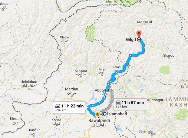
Gilgit Baltistan is well connected with Islamabad the capital city of Pakistan by road. Northern Areas Transport Corporation (NATCO) runs daily bus services from Islamabad. For seat reservation call: 051-9278441. or 051-9278442Google Road Map
Road map from Islamabad to Gilgit via Mansehra and Muzaffarabad.
Friday, 12 January 2018
TOP DESTINATIONS IN HUNZA DISTRICT, ASTORE AND GHIZER DISTRICTS

Passu Valley
Passu lies between Batura & Passu Glaciers. The famous natural beauty of Passu is Tupopdan Peak, also known as "Passu Cones", having picturesque shape is one of the most photographed peaks in the region.

Gulmit Valley
Anybody who wants to take the experience of looking at the best landscapes, must visit Gulmit. A walk through the valley exposes you to over 100 varieties of flora and fauna all of which are pervasive through this region.

Skardu Valley
Skardu is surrounded by dry rugged, snow-capped mountains and sand dunes. The place is famous for trekking and adventure spots. The near by Satpara Lake and Shangrila resort are attraction spots for tourists.

Khaplu Valley
Khaplu valley is a base for trekking into the Hushe valley. The valley is attractive for mountaineers and trekkers as it is surrounded by several famous mountain peaks like Mashabrum, Sharpi Gangri, Sia Gangri and Saltoro Gangri.
TOP DESTINATIONS IN GILGIT DISTRICT Pakistan

Bagrote Valley
A small valley surrounded by high mountains makes it the perfect place for trekking. It is a place less known when compared to any other nature spots in Gilgit Baltistan, but surely will leave you with a much enhanced nature treatment like the others.

Danyore Valley
If you are an adventure junkie, then you should not miss out on the experience of Danyore suspension bridge. The bridge constructed over a half century ago and it enters a tunnel constructed by locals without any proper civil engineering equipments.
Traditional Foods And Drinks In Gilgit Baltistan, Pakistan
Gilgit Baltistan cuisine is as diverse as it is unique. Some of Gilgit Baltistan more famous traditional
food dishes are Chapshoro, Dawdoo, Chamus, Mamtoo, Sharbat, Harisa, Molida, Garma, Berikutz
,Harissa, Diram, Mull, Gooli, Suppra, Khamuloot.
food dishes are Chapshoro, Dawdoo, Chamus, Mamtoo, Sharbat, Harisa, Molida, Garma, Berikutz
,Harissa, Diram, Mull, Gooli, Suppra, Khamuloot.

Chapshuro
Chapshuro is one of the most delicious dish of Gilgit Balistan. It is filled with chopped meat (lamb, beef), onion, chile peppers, tomato and fresh coriander leaves.

Mamtu
Mantu (dumpling) is steam boiled dish which is filled with chopped meat (lamb, beef), onion, chile and garlic and steamed for several hours in in a multi layer steamer.

Harissa
Harissa is prepared by wheat, meat and butter as a oil .The dish is solid in the handling of proteins and it is served on extraordinary events including wedding functions, celebrations.

Sharadi
Sharadi/Garma is one of the many healthy dishes from Gilgit Balistan. It is simply raw wheat dough thin pitas cooked in china cabbage.

Sharbat
Sharbat is one of healthy dish from Gilgit Balistan. It is prepared by wheat and butter. It is high in protein and served on wedding celebrations.

Gooli
Flat bread, made with wholegrain flours, rich in vitamin B-17. it is served spreading butter on bread, on extraordinary events.

Chupati
Chupati (bread) is a must item for Gilgit Baltistan people in breakfast, made with wheat flour and is baked at night and served in morning with salty tea.

Diram
Diram Fiti bread made from sprouted wheat flour which give natural sweetness. It is served mixing butter, almond or apricot oil.
source: http://mygilgit.com/gilgit-baltistan/foods-to-eat.php
Saturday, 6 January 2018
Geography of Gilgit–Baltistan Pakistan
Gilgit-Baltistan has been under Pakistan administration
since 1947 and was given self-governing status on August 29, 2009.[1]Gilgit-Baltistan
comprises 10 districts within
three divisions. The four districts of Skardu Kharmang
Shigar and Ghanche are
in the Baltistan Division,
four districts of Gilgit Ghizer Hunza and Nagar districts
which were carved out of Gilgit District are in the Gilgit Division
and the third division is Diamir,
comprising Chilas and Astore (which
was carved out of the Diamir District in 2004). The main political centres are
the towns of Gilgit and Skardu.
Gilgit-Baltistan is home to some of the
world's highest mountain ranges. The main ranges are the Karakoram and
the western Himalayas. The Pamir mountains
are to the north and the Hindu Kush lies to the west. Amongst the highest
mountains are K2 (Mount
Godwin-Austen) and Nanga Parbat, one of the most feared mountains in the world.
Many of the highest peaks in
Gilgit-Baltistan, such as Baltoro Muztagh,
K2 (Mount Godwin-Austen) (8,611 m), the second-highest mountain in the world),
the Gasherbrums (7,932
- 8,080 meters, ranked 12-17 in the world), and Masherbrum (7,821
m), 22nd-highest in the world), lie in the Skardu District.
Other high peaks are Distaghil Sar (7,885 meters, 19th-highest in the world), Kunyang Chhish (7,852
meters, 21st-highest in the world), Batura Sar (7,795
m), 25th-highest in the world), Kanjut Sar (7,790
m), 26th-highest in the world), and Rakaposhi (7,788
m), 27th-highest in the world.
Gilgit District

The Gilgit District is bounded by the Wakhan Corridor of (Afghanistan) in the north, Xinjiang (China) in the north and northeast, Skardu District in the south and southeast. The capital of the Gilgit District is Gilgit town.
The district includes Gilgit town, Naltar,
Nagar State Hunza, Gojal (Upper Hunza) and Shimshal.
It also includes many small villages like Minapin, Hopar,
and HisparNgar
KHaas, Symayer, Askurdas, Shahyaar, Hakochar, Phaker, Dadimal, Miacher, Pisson,
Yell, Ghulment, Masoot, Thole, Nilt, Jafferabad, Sikandarabd, Chalt Chaproat,
Bodlas in the Ex. State of Nagar. The Haramosh valleyhaving eight(8) villages
i.e. Hanuchal, Shota, Sassi, Daso, Hurban, barchy, jutiyal, and khaltaro,
currently located within the Gilgit District, was previously located within the
Skardu District. Gojal (Upper Hunza) Gulmit Gojal is the last tehsil there and (Sost)
is the last stop of (Pakistan). Sost is the place where (Pak-China Dry
Port) is located near a village (Hussainabad). The highest peak in the Gilgit District is Distaghil Sar (7,885
m), which is the 19th-highest mountain in the
world.
HUNZA VALLEY

Rivers in Gilgit District
Main
rivers in the Gilgit District are:
· Khunjerab River - flows south along the Karakoram Highway from the Khunjerab Valley and is known as the Nagar River, Hunza River south of Sust.
· Nagar River - flows further south and enters
the Gilgit River by
touching Hunza River to Gilgit
· Hunza River - flows further south and enters
the Gilgit River just
to the northeast of Gilgit town.
· Gilgit River - enters the Gilgit
District from the west, south of the Bichhar Pass (Naltar Valley), and flows west
through Gilgit town.
· Indus River - enters the Gilgit
District from the Skardu District about
six kilometers north of Jaglot, where the
Indus River is joined by the Gilgit River. From there, the Indus flows
south along the Karakoram Highway.

Skardu District

The capital of the Skardu District
is Skardu town. Skardu was part of Ladakh
before the partition of Kashmir in 1948. The Baltoro Muztagh, the subrange of the Karakoram that includes the mighty peaks
of K2 (8,611 m), Broad Peak (8,047 m), the Gasherbrums (8,000+ meters) and Masherbrum (7,821 m), is included in the
Skardu District. Askole is the last
settlement in the district for all treks to Concordia,
the confluence of the Baltoro Glacier and the Mount Godwin-Austen Glacier). The Biafo Glacier and a major part of
the Hispar Glacier are
also located in the Skardu District. The district also includes almost all of
the Deosai National Park,
which is located on the second-highest plateau in the world. (Only the Tibetan
Plateau is higher). Skardu also is the district in which the Indus River enters Gilgit-Baltistan from
the Indian state of Jammu and Kashmir.
Other towns in the Skardu District
include:
· Gamba Skardu, Shigar Khas, Mehdi Abad, Sermik, Stak, Gulab Pur, Kharmang Khas, Kachura, Gultari, and Thowar.
The highest peak in the Skardu
District is K2 (8,611 m), which is the second-highest peak
in the world.
Hispar Pass and Gondoghoro
Pass are also in the Skardu District. Some of the lakes in the
district are Snow Lake, Satpara Lake, Sheosar Lake, Kachura Lake, and Shangrila Lake.
Ghanche District

The Ghanche District
("Ghanche" means the 'great glacier' and is written as
"Gangche" by the local people) is the easternmost district of Baltistan.
To the east is the Leh District of Ladakh( under
administration of India).[2][3][4] To the Northeast
is Xinjiang (China), to the north and
northwest is the Skardu
District, to the west is the Astore District, and to
the south is Ladakh(Indian state of Jammu and Kashmir.) The Actual Ground Position Line (AGPL)
at the easternmost part of Ghanche District is located across the Saltoro Ridge. The Line of Control along
the easternmost region of the Ghanche District ends before the start of the Siachen Glacier (entirely
under control of India)
at NJ9842. There has been a
proposal made to turn the Siachen Glacier region
into a peace park.
The capital
of the Ghanche District is Khaplu.
The Khaplu and Hushe Valleys form
the gateway for the great Baltoro Muztagh, the
subrange of the Karakoram that
includes the mighty peaks of K2 (8,611
m), Broad Peak (8,047 m),
the Gasherbrums (8,000+
meters), and Masherbrum (7,821
m)--all of which are located in the Skardu District.The
highest peak in Ghanche District is Saltoro Kangri (7,742
m), which is the 31st-highest peak in
the world and is, in fact, under Indian control since 1984.
Some rivers
in the district are the Shyok River,
the Hushe River, and the Thalle River.
Ghizar District

The Ghizar District is the westernmost
district of the Gilgit-Baltistan. It is bounded by Pakistan's Khyber Pakhtunkhwa province
on three sides (north, west, and south), by the Diamir District in the south and
southeast, and by the Gilgit District in the east. A small strip of the Ghizar
District (roughly 35x12 km) is sandwiched between the Khyber Pakhtunkhwa and
the Wakhan Corridor of (Afghanistan). The capital of the Ghizar
District is Gakuch.
The highest peak in the Ghizar District
is Koyo Zum (6,871
m) in the (Hindu Kush Range) which lies on the
boundary of the Ghizar District and the Khyber Pakhtunkhwa.
Some of the main places in the district are
the Gulapur, singul, Ishkoman, and the Yasin valleys. Other places include Gupis, Chatorkhand, Imit,
and Utz.
Some of the passes in the district are:
The main river in the district is the Ghizar River,
which is known as the Gilgit River to the
east of Gupis town. Some of its tributaries
include the Karambar
River, the Ishkoman
River, the Phakora River,
and the Hayal River.
Subscribe to:
Posts (Atom)